Introduction
GoldQuest has defined a zone volcanic-hosted massive sulfide mineralization in the western Dominican Republic. The Company discovered several new zones of new mineralization on its wholly-owned Las Animas project by stream sediment sampling and geological mapping.
Mineral Resources: Las Animas NI 43-101 Mineral Resources*
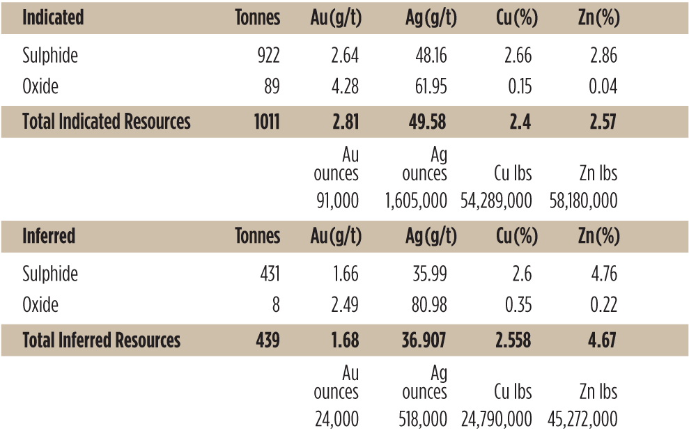
* see footnotes below
Technical Report: Las Animas NI 43-101 Resource Report (6 MB)
Target Minerals: Copper, Gold, Silver & Zinc
Ownership
The project comprises of two claims one which has full title and a second currently under reapplication.
Location & Access
Las Animas is located just over 100 kilometres north-west of the capital Santo Domingo. Access is excellent with several good roads enabling access to the centre of the project.
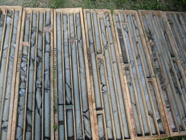
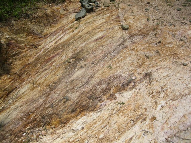
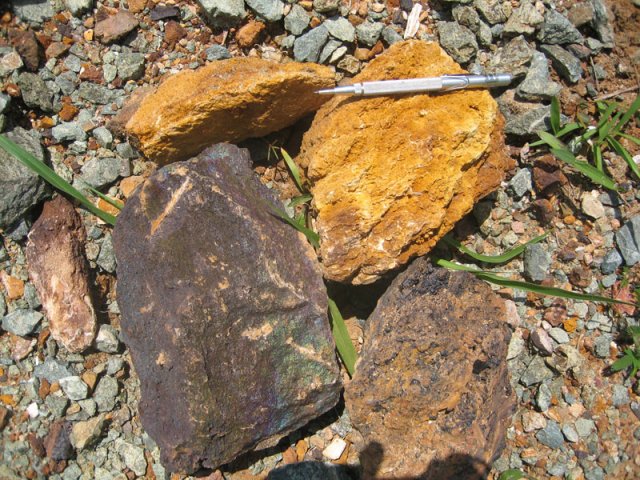
Geology and Sampling
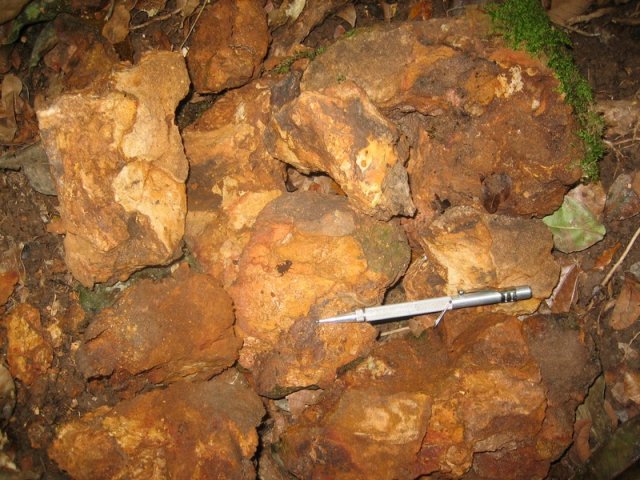
Initial sampling of gossan blocks from an old mine working gave an average of 6.61 g/t Au and 48.44 g/t Ag in nine samples. Fieldwork by GoldQuest geologists discovered outcropping gossan located in a heavily overgrown area of on old mine working. The gossans returned channel samples results of 6.45 metre grading @ 11.85 g/t Au and 18.59 g/t Ag (composite of continuous 1.0 to 1.45 metre channel samples) with a peak value of 24.0 g/t Au over 1.0 m. Channel samples of an oxidized quartz-sulfide stockwork in sericite schists in the mine and road cuts gave results which included 18.0 metres grading 2.73 g/t Au and 34.92 g/t Ag including eight metres grading 5.87 g/t Au and 71.15 g/t Ag.
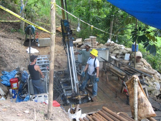
Drilling Results (expand)
The first three diamond drill holes were drilled on the same north-south fence with LA-01 and 02 at inclinations of -65° and -50° respectively and LA-03 drilled 40 metres north at an inclination of -50°.
LA-01 intersected supergene copper with a grade of 2.22% over four metres from 48.0 to 52.0 metres.
LA-02, drilled at a shallower angle, intersected the oxide gold zone with 38 meters grading 1.92 g/t Au (from 34.0 to 72.0 m) with a high grade interval of 6.90 g/t Au over 9.68 metres from gossan. The peak value from this interval returned 12.75 g/t Au over one metre. Base metals are leached in this oxide intersection.
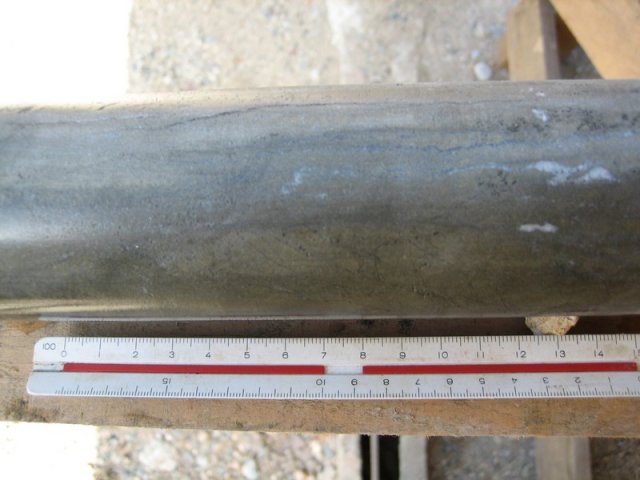
LA-03, drilled deeper below LA-01 and 02, intersected massive sulfides at a depth of 100 metres below surface at 96.35 metres down hole. The 9.65 metres intersection from 96.35 metres graded 1.22 g/t Au, 51.84 g/t Ag, 2.25% Cu and 4.14% Zn. The massive sulfide mineralisation principally comprises pyrite, chalcopyrite, chalcocite, sphalerite and bornite.
Holes LA-04 and 05 were drilled on the same north-south geological section as holes LA-01, 02 and 03 and intercepted massive sulfide mineralization at depth beneath hole LA-03, increasing the continuity of the mineralization to 150 metres below surface.
LA-04 intersected 6.66 metres of semi-massive sulfide from 123.19 to 129.85 metres grading 2.44% Cu, 2.98% Zn and 8.78 g/t Au and 84.55 g/t Ag.
LA-05 cut massive sulfides 50 metres vertically below LA-04 and returned 9.74 metres from 157.22 to 166.96 metres grading 2.06% Cu, 6.24% Zn, 1.52 g/t Au and 47.8 g/t Ag.
LA-06 was drilled 30 metres west of holes LA-01 to 05 and intercepted a similar gossanous sequence to that observed in hole LA-02. This interval cut 10.18 metres from 50.80 to 60.98 metres grading 8.84 g/t Au and 60.00 g/t Ag and is leached of base metals. It was followed by a 10.65 metre void to 71.63 metres interpreted to be a historical mine working.
LA-07 was drilled 45 metres east of Holes LA-01 and 02 and intercepted a thin horizon of gossan at the sediment-volcanic contact. The gossan returned 0.51 metres grading 2.62 g/t Au from 46.05 metres and the footwall volcanics returned 23.44 metres grading 0.36 g/t Au from 46.56 metres, including 10.00 metres at 0.55 g/t Au from 56.00 metres.
LA-08 was a short 55.81 metres hole drilled to the south on the same section as holes LA-01, 02, 03, 04 and 05. The hole intercepted sanded barite gossan and gossanous sediments and sericite schist at the sediment-volcanic contact that returned 16 metres grading 3.01 g/t Au and 19.08 g/t Ag in oxide from surface, including 2.81 metres grading 12.24 g/t Au and 35.57 g/t Ag in gossan from 12.19 metres. Base metals have been leached from this interval. The rest of the hole is in pyritic sericite schist and gave 0.28 g/t Au and 3.53 g/t Ag over 39.81 metres from 16.00 metres, including a semi-massive sulfide intersection of 4.44 metres grading 0.63 g/t Au and 6.06 g/t Ag from 36.26 metres.
LA-09 was drilled to test a conductive geophysical target located 80 metres southeast of holes LA-05 and intercepted sericite-pyrite altered rhyolite volcanic rocks with a maximum value of 0.63 g/t Au.
LA-10 was drilled 56 metres north of LA-06 on the same geological cross section with an azimuth of 180 degrees and an inclination of -60 degrees in order to test the continuity of sulfides at depth below the gossan intercepted in hole LA-06.
The hole intersected massive sulfides consisting of chalcopyrite, sphalerite and pyrite vertically below the gossan of LA-06. The hole then continued in massive sulfides and sulfide-rich sericite schist to a depth of 304.00 metres.
The massive sulfide and stockwork interval returned:
- 142.00 metres grading 2.50 g/t Au, 36.58 g/t Ag, 2.59% Cu and 1.91% Zn from 162.00 metres to 304.00 metres. Including,
- 14.56 metres grading 4.20 g/t Au, 85.99 g/t Ag, 3.13% Cu and 3.29% Zn from 163.02 metres to 177.58 metres And
- 105.98 metres grading 2.72 g/t Au, 36.75 g/t Ag, 2.29% Cu and 2.09% Zn from 198.02 metres to 304.00metres.
This drill intercept can be explained by folding and structural thickening of the massive sulfide layer in an asymmetric S-shaped fold (looking east), with a near vertical body on the upper and lower fold limbs, and an intermediate limb with a similar dip as the drill hole. The remainder of the hole was in pyritic sericite schist to the final depth of 330.79 metres.
LA-11 was drilled 98 metres south of LA-01 from the same platform as LA-04 and 05 with azimuth of 360 degrees north and inclination of -75 degrees to test the down-dip continuity of the massive sulfides. It drilled through the footwall sericite schists with several strongly pyritic intervals to a depth of 199.40 metres but failed to reach the massive sulfide target due to technical drilling difficulties in a large zone of soft sericitic clay. After several attempts to complete the hole the decision was taken to abandon the hole at 140.25 metres.
LA-12 was drilled at an azimuth of 225 degrees and inclination -65 degrees. It was collared in hangingwall siltstones with the target being massive sulfides at depth along strike to the west from hole LA-10. The hole stayed in siltstones to the end (202.45 metres) with siliceous, beige coloured altered siltstones with quartz-brown carbonate veining similar to the sediments immediately overlying massive sulfide in other holes. The geological sequence has been folded and overturned at depth with a dip of 60 to 65 degrees which is shallower than expected so the hole did not reach the desired volcanic - sedimentary contact where the majority of sulfides occur.
LA-13 is located 81 metres south of LA-06, and was drilled to the north at an inclination of -80 degrees as a cross "Scissor hole" to test the geometry and thickness of the massive sulfides intersected in hole LA-10. The hole intersected massive sulfides over 19.09 metres from ~222.0 metres to 241.09 metres which is estimated as being closer to the true width of the massive body intercepted in hole LA-10. The massive sulfides are preceded by sericite schist with ~5% disseminated pyrite with an increase to 10-20% disseminated pyrite from ~214.0 to ~222.0 in the footwall to the massive sulfides. The massive sulfides are followed by well bedded siltstones from 241.09 metres to the end of the hole at 245.44 metres. Hole LA-13 confirms that the massive sulfides intersected in hole LA-10 are a single body which has been folded helping to explain the intersection in hole LA-10.
LA-14 was drilled on the western anomaly 420 metres west of LA-06. The target was gossans in sericite schist with anomalous gold in rock chip sampling returning 21.30 g/t and 9.17 g/t gold (Press release May 8, 2007). LA-14 was drilled 350 degrees north at inclination of -55 degrees to 144.83 metres depth. It intercepted sericite schist to ~63.0 metres with intervals of breccia textured rhyolite and folding. It has hematite oxidation and gossanous zones at 31.5 - 33.0 metres, 37.5 - 38.3 metres, 40.0 - 41.0 metres, and 48.0 - 49.0 metres. This is followed by bedded rhyolite hyaloclastite sandstone, with coarser clasts, with illite alteration, hematite oxidation and weak bedding-parallel foliation.
LA-15 was drilled 35 metres north of LA-14 at an azimuth of 195 degrees south and inclination of -46 degrees as a "scissor-hole" to LA-14. It is entirely in massive to schistose rhyolite with sericite alteration. It is all oxidized and has gossanous intervals with hematite. From 0 to ~11.0 metres it is massive with hematite oxidation and flow banding at 70 degrees to the core axis. To 45.74 metres the sericite alteration becomes stronger. From 45.74 to 55.80 metres it is massive rhyolite, and to the end of the hole at 57.82 metres it is a folded bedded rhyolite hyaloclastite. There are gossans at 29.0 to 29.5 metres (jarosite), 30.5 to 31.0 metres (hematite), 32.5 to 33.5 metres (hematite), and 57.0 to 57.1 metres.
LA-16 was drilled 57 metres SW of LA-14 to test anomalous gold in gossans in sericite schist. It was drilled at an azimuth of 360 degrees north and inclination of -50 degrees for a length of 100.62 metres. The hole was entirely in quartz-plagioclase rhyolite which varies from massive flows with intervals of bedded hyaloclastite sandstone and breccia. Alteration is to pale green illite and possibly chlorite, with more sericitic alteration in hyaloclastite units. The depth of hematite oxidation is 60.7 metres. There is gossan at 42.6 to 44.5 metres (goethite after 25% pyrite) in a hyaloclastite breccia, and gossanous intervals between 47.26 and 60.7 metres 910 to 25% goethite and hematite). Sericite schist after the base of oxidation has 5 to 10% pyrite (60.7 to 68.5 metres), becoming lesser at depth.
LA-17 was a short hole drilled 22 metres SW of LA-12 and was drilled vertically to a depth of 42.69 metres. It intersected rhyolite and sericite schist to ~31.0 metres. The rhyolite has quartz and plagioclase phenocrysts and is a massive to foliated lava which has a combined flow foliation or hyaloclastite sandstone bedding and weak schistosity. It has saprolitic weathering with a bleached, soft clay zone to 12 metres depth, followed by a hematitic zone to ~17 metres, then brown goethite oxidiation with black manganese oxides on fractures. Alteration below the hematite zone is pale green illite with possible epidote. These are followed by conformable laminated, white to green siltstones, which become darker gray and siliceous from ~39 metres. The entire hole is in the oxide zone.
Hole LA-18 is a short hole with an azimuth of 020 degrees and an inclination of -75 degrees. The target was to test the massive sulfides along strike to the west of the El Yujo zone and outcropping gossan exposed a stream. The hole intersected sericite schist to 58.91 metres, followed by 0.21 metres of semi-massive sulfide from 55.91 to 56.17 metres, comprising chalcopyrite coated by and partly replaced by dark gray chalcocite, with barite and sericite. This was followed by ~0.83 metres of sericite schist with quartz eyes to ~57.0 metres, and then by sediments to the end of the hole at 65.55 metres. The stratigraphy is overturned and correlation with the exposed gossan shows that the massive sulfide horizon has an apparent dip of 40 degrees to the SSW.
LA-19 is 60 metres SW of hole LA-06 with an azimuth of 360 degrees, inclination of -50 degrees and length of 71.65 metres. The hole intersected quartz eye sericite schist to ~59.0 metres, followed by ~3.50 metres of gossan after massive sulfide from ~59.0 to 62.50 metres, then by a void of 3.58 metres from 63.50 to 67.08 metres, interpreted to be an old mine adit. This is followed by dark gray, siliceous, finely bedded siltstones from 67.08 metres to the end of the hole at 71.65 metres. The base of the oxidation zone in 22.37 metres and is followed by 2 to 3% pyrite in sericite schist, with an increase to 5 to 10% pyrite in sericite schist after a rhyolite breccia from 42.5 to 59.0 metres. The gossan is ochre colored and crumbly with goethite, jarosite and barite. It starts in the drill run between 57.93 and 59.46 metres which has only 21% recovery. It is not possible to give a precise start depth for the gossan which starts in the interval between 58.13 metres and 59.34 metres, average 58.74 centimetres.
LA-20 was drilled from the same platform as LA-19 with the same azimuth of 360 degrees and a steeper inclination of -65 degrees and length of 120.44 metres. The hole intersected two massive sulfide intervals interpreted to be a reverse fault or possible fold repetition of the same massive sulfide body. The top interval after 72.60 metres of footwall sericite schists and comprises:
- ~72.60 - ~74.00 metres: Sericite and goethite, possible fault.
- ~74.0 - 80.7 metres: Barite sand and jarosite. Very low recovery due to soft sanded nature.
- 80.7 - 82.22 metres: Banded massive sulfide with supergene chalcocite & covellite.
- 82.22 - 83.32 metres: Barite-jarosite
- 83.32 - 83.85 metres: Non-banded massive sulfide with abundant chalcocite.
This is followed by probable fault zone from 83.85 to ~88.00 metres with broken sediments with sericite alteration, possible barite and low recovery to ~85.0 metres; followed by hangingwall siltstones from ~88.0 to 98.75 metres. The second massive sulfide intersection is as follows:
- 98.75 - 100.62 metres: Massive sulfide, bedded and massive, with only 42% drill recovery.
- 100.62 - 101.26 metres: Sericite-altered rhyolite with 2% pyrite, non-schistose.
- 101.26 - 102.30 metres: Bedded massive sulfide with barite.
- 102.30 - 106.54 metres: Non bedded massive sulfide.
This is followed by slickensided sericite schist with 5% pyrite and chalcocite and quartz veins (106.54 - 107.40 metres); then by siltstones from 107.40 metres to the end of the hole at 120.44 metres.
The barite / massive sulfide horizons in holes LA-19 and LA-20 is interpreted to be a single body with a dip of ~75° south. The stratigraphy is overturned. The mineralized horizon is estimated to have been displaced by a reverse fault with an estimated throw of ~18 metres at a dip of 35 to 40 degrees south.
Hole LA-21 was drilled 27 metres south of LA-19 and LA-20 on the next fence west of LA-26. The hole has an azimuth of 360 degrees, inclination of -70 degrees and a length of 161.72 metres. It intercepted sericite schist with pyrite to 131.78 metres followed by 5.79 m of massive sulfide. This consists of pyrite, chalcopyrite, sphalerite and barite (with core angle of bedding of 25 - 50°) and is followed by hangingwall siltstone to the end of the hole.
The massive sulfide returned 5.79 meters grading 3.66% Cu, 5.24% Zn, 14.77 g/t Au and 120.81 g/t Ag and includes one sample with 55.9 g/t Au. Mineralization extends into the hanging wall and footwall and is part of a wider interval of 24.0 m at 3.66 g/t Au, 30.09 g/t Ag, 1.47% Cu and 1.44% Zn. The intersection is correlated with the lower massive sulfide interval intercepted in hole LA-20 to give the body a dip of 55 degrees south with overturned stratigraphy.
LA-22 was drilled 11 metres north of hole LA-07 with azimuth to the south at an inclination of -65 degrees to test the continuity of the mineralized horizon below that intercepted in LA-07. The hole was collared in hanging wall siltstones to 53.20 metres. There is 2.74 metres of sulfide-rich sericite schist at 47.26 metres to 50.0 metres, with 25% pyrite coated by chalcocite. It is oxidized from 48.7 metres. This is followed by 3.20 metres of siltstones (50.00-53.20 metres) and a 0.40 metres quartz vein. Sericite schist starts at 53.60 metres and continues to the end of the hole at 100.62 metres. The hole returned 64.22 metres grading 0.31 g/t Au from 36.42 to 100.62 metres. The mineralized horizon is represented by sulfide-rich sericite schist. This section shows a downwards facies transition from barite with sulfides (now gossan) on surface in LA-07, to sulfidic sericite schist in LA-22.
Hole LA-23 was drilled 53 metres SSW of LA-18 and 18 metres west of LA-21. It was drilled at an inclination of -75 degrees to the NNE for a length of 213.43 metres. The hole cut rhyolite and sericite schist with alteration intensity decreasing down-hole. The contact with the hangingwall siltstone was reached at 208.75 metres, indicating a steepening of the contact from 40 degrees to about 80 degres south. The stratigraphy is overturned and no mineralization was present at the contact although there are sulfide rich zones within the sericite schist. The hole returned two intervals of mineralization within sericite schist including 18 metres grading 0.29% Zn (from 42.00 to 60.00 metres) and 20 metres grading 0.24% Zn (from 190.0 to 210.00 metres).
LA-24 was a vertical hole drilled to the south of LA-17 to 91.47 metres depth. The hole cut rhyolite with a decrease in intensity of alteration downhole from sericite schist in the upper part to illite altered rhyolite and transition to chlorite alteration. The sericite and illite alteration have up to 5% disseminated coarse pyrite. The contact with black carbonaceous siltstone is at 83.70 metres with trace pyrite and 2% goethite. No massive sulphides were intercepted in this hole but the contact zone returned 10.42 metres grading 0.44% Zn from 81.05 metres to the end of the hole. The zinc values and the alteration in the LA-24 hanging wall sediments correlate with those drilled in hole LA-12 which returned 60.45 metres grading 0.48% Zn.
LA-25 was drilled on the western gossan, 19 metres north of hole LA-15 and inclined at -55 degrees to the south below LA-15, below the gold-bearing gossan outcrop, and across LA-14 to test the mineralization at greater depth. The hole was entirely in rhyolite to the final depth of 167.68 metres. There is a 0.93 metres interval of massive sulfide between 102.14-103.07 metres with a massive texture and medium grain size. The hole did not return any significant values.
Hole LA-26 was drilled as a deep perpendicular "scissor hole" below hole LA-10 to test the continuity of the massive sulphides at depth. The hole was collared 74 metres south of LA-13 and was drilled in a northerly direction at an inclination of -77 degrees.
The hole cut rhyolite with increasing alteration to sericite schist down-hole, followed by massive sulfides, then siltstone hangingwall. The upper part of the hole to 265.1 metres is in massive rhyolite with sericite alteration, followed by pyritic sericite schist. There are localized banded, semi-massive to massive sulfide zones of pyrite replacing the matrix of hyaloclastite breccias. Bedding is typically at ~40 degrees to the core axis. The massive sulfide intersection extends from 330.70 to 398.47 metres and comprises pyrite, chalcopyrite, sphalerite and barite. This returned 67.77 metres grading 3.38% Cu, 3.98% Zn, 1.49 g/t Au and 26.52 g/t Ag. The massive sulfide in the first (stratigraphically lowest) part is massive textured interpreted as replacement, followed by a thicker zone that is poorly bedded and brecciated which is interpreted as bedded sea-floor exhalative with slumping, which may be related to the basin deepening. The upper part is bedded with exhalative and volcanic sediments.
The massive sulfides are followed by (overlain by) white siliceous and sericite altered siltstone for 5.65 metres to the end of the hole at 404.12 metres. The hole cut the massive sulfide at an angle of approximately 20 degrees, indicating that the body dips 85 degrees to the south and is overturned with an estimated true thickness of about 20-25 metres.
LA-27 is located 45 metres northwest of LA-26 and was drilled to test the down dip extension of that intercepted in drill holes LA-19, 20 and 21. LA-27 was drilled to the north with a -70 degrees dip and a total depth of 248.49 metres. The hole was drilled from the footwall volcanics towards the hangingwall sediments and intercepted 7.15 metres of massive sulphide mineralization from 220.00 to 227.15 metres grading 7.36 g/t Au, 72.51 g/t Ag, 2.71 % Cu and 5.22% Zn. This intercept extends massive sulphide mineralization 75 metres down-dip from LA-21.
LA-28 is located 80 metres southwest of LA-12 and was drilled as a "scissor hole" to test the sediment-volcanic contact at depth beneath hole LA-12 which did not cross the sediment-volcanic contact but returned 60.45 metres grading 0.49% Zn in the hangingwall sediments suggesting the possibility of another nearby massive sulphide body. LA-28 was vertical hole drilled to a depth of 189.04 metres. The hole crossed the contact at 157.50 metres without hitting massive sulphide mineralization but returned 22 metres grading 0.86% Cu including 6 metres grading 1.30% Zn from the hangingwall sediments. It is the Company's belief that this may represent a deeper as yet blind body and it is the intention of the Company to test this zone with further drilling at depth and along strike.
LA-29 is located 375 metres west of LA-26 and was drilled to test anomalous soil sample geochemistry. LA-29 was drilled at an azimuth of 045 degrees a dip of -65 degrees to a depth of 196.66 metres. The hole remained in sericitic altered felsic volcanics and intercepted an interval of 84 metres grading 0.32% Zn with a maximum of 2 metres grading 2.72% Zn.
LA-30 is located 110 metres west-southwest of LA-12 and was drilled to test a mapped fold hinge on the sediment-volcanic contact between the "Western Zone" and hole LA-12 which returned 60.45 metres grading 0.45% Zn in hangingwall sediments. LA-30 was drilled at an azimuth of 315 degrees and a dip of -75 degrees to a depth of 74.70 metres intercepting the sediment-volcanic contact at 46.74 metres. No mineralization was intercepted at the contact.
LA-31 is located 52 metres south of holes LA-04, 05 and 11 and was drilled to test the down-dip extension of the massive sulphide mineralization intercepted in those holes. LA-31 was drilled to the north with a -65 degrees dip and a total depth of 285.39 metres. The hole started in sericitic altered footwall volcanics intercepting an upper zone grading 26 metres at 0.35 g/t Au from 136.00 to 162.00 metres. At depth, the hole intercepted 6.48 metres of massive sulphide mineralization from 270.22 to 276.70 grading 2.74 g/t Au, 73.13 g/t Ag, 1.58% Cu and 5.43% Zn before entering the typical hangingwall sedimentary sequence. This intercept extends massive sulphide mineralization 85 metres down-dip from hole LA-11.
LA-32 is located 104 metres northeast of LA-07 and was drilled to test the westward extension of mineralization at the sediment-volcanic contact and the hinge zone of a large fold. Hole LA-32 was collared in the hangingwall sediments and drilled on an azimuth of 225 degrees with a dip of -65 degrees to a total depth of 114.32 metres. The hole intercepted the sediment-volcanic contact at 91.46 metres and no massive sulphide mineralization was present.
LA-33 is located 111 metres northwest of LA-29 and 246 metres southwest of LA-30 and was drilled to test a zone of anomalous soil sample geochemistry. LA-33 was drilled at an azimuth of 045 degrees and a dip of -55 degrees to a total depth of 138.71 metres.
LA-35 was drilled from the footwall felsic volcanics directly east of LA-26 at an angle of -69 degrees and an azimuth of 360 degrees to a total depth of 331.93 metres. The hole intercepted the typical sequence of felsic volcanics before intercepting massive sulphide between 321.85 to 331.93 metres. The interval returned 10.08 metres grading 2.29 g/t Au, 3.76 % Cu, 3.62 % Zn and 51.84 g/t Ag. This intercept has confirmed the presence of massive sulphide at depth 30 metres east of hole LA-26 and 37.40 metres vertically below LA-31.
LA-36 was drilled directly east of LA-26 at an angle of -70 degrees and an azimuth of 360 degrees to a total depth of 229.61 metres. This hole reached the desired depth and intercepted the anticipated geological sequence. The hole which was drilled from the footwall volcanics intercepted massive sulphide between 255.57 and 260.36 metres before entering the hangingwall sedimentary sequence. The massive sulphide interval returned 4.79 metres grading 2.50 g/t Au, 2.77 % Cu, 5.45 % Zn, and 49.63 g/t Ag.
LA-38 was drilled directly south of LA-26 at an angle of -65 degrees and an azimuth of 360 degrees. This is the deepest hole completed on the property to date and was drilled to test for massive sulphide directly below the previously reported hole LA-26 which returned an intercept of 67.77 metres grading 3.38% Cu, 3.98% Zn, 1.49 g/t Au and 26.52 g/t Ag.LA-38 intercepted 631.20 metres of sericitic rhyolites before crossing 0.71 metres of semi-massive sulphide interpreted to be the down-dip extension of the massive sulphide body intercepted in hole LA-26. This interpretation is significant since it extends the zone 153 metres vertically below LA-26, which now suggests continuous mineralization 516 metres from surface.
| Drill Hole | From (m) | To (m) | Length (m) | Gold (g/t) | Silver (g/t) | Copper (%) | Zinc (%) | Oxide / Sulfide |
| LA-01 | 48.00 | 52.00 | 4.00 | 0.25 | 9.63 | 2.22 | 0.14 | Transition |
| LA-02 | 34.00 | 72.00 | 38.00 | 1.92 | 8.34 | nsv | nsv | Oxide |
| Including | 36.00 | 45.68 | 9.68 | 6.90 | 21.56 | 0.01 | nsv | Oxide |
| LA-03 | 96.35 | 106.00 | 9.65 | 1.22 | 51.84 | 2.25 | 4.14 | Sulfide |
| LA-04 | 123.19 | 129.85 | 6.66 | 8.78 | 84.55 | 2.44 | 2.98 | Sulfide |
| LA-05 | 157.22 | 166.96 | 9.74 | 1.52 | 47.80 | 2.06 | 6.24 | Sulfide |
| LA-06 | 50.80 | 60.98 | 10.18 | 8.84 | 60.00 | nsv | nsv | Oxide |
| LA-07 | 0.00 | 4.00 | 4.00 | 1.51 | 3.56 | 0.03 | 0.01 | Oxide |
| 46.05 | 46.50 | 0.51 | 2.63 | 170.50 | 0.04 | 0.01 | Oxide | |
| 46.50 | 70.00 | 23.44 | 0.37 | 23.00 | 0.05 | 0.24 | Oxide | |
| including | 56.00 | 66.00 | 10.00 | 0.55 | 19.82 | 0.03 | 0.43 | Oxide |
| LA-08 | 0.00 | 16.00 | 16.00 | 3.01 | 19.08 | 0.05 | 0.03 | Oxide |
| Including | 12.19 | 15.00 | 2.81 | 12.24 | 35.57 | 0.10 | 0.40 | Oxide |
| 16.00 | 55.81 | 39.81 | 0.28 | 3.52 | 0.05 | 0.01 | Oxide | |
| including | 35.56 | 40.00 | 4.44 | 0.63 | 6.06 | 0.08 | 0.01 | Oxide |
| LA-09 | 138.00 | 140.00 | 2.00 | 0.64 | 3.22 | 0.06 | 0.05 | Sulfide |
| LA-10 | 162.00 | 304.00 | 142.00 | 2.50 | 36.58 | 2.59 | 1.91 | Sulfide |
| including | 163.02 | 177.58 | 14.56 | 4.20 | 85.99 | 3.13 | 3.29 | Sulfide |
| And | 198.02 | 304.00 | 105.98 | 2.72 | 36.75 | 2.29 | 2.09 | Sulfide |
| LA-11 | 34.00 | 56.00 | 22.00 | 0.42 | NSV | NSV | 0.64 | Sulfide |
| LA-12 | 142.00 | 202.45 | 60.45 | NSV | NSV | NSV | 0.49 | Sulfide |
| Including | 164.00 | 202.45 | 38.45 | NSV | NSV | NSV | 0.63 | Sulfide |
| LA-13 | 222.00 | 241.09 | 19.09 | 2.03 | 33.01 | 3.08 | 3.91 | Sulfide |
| LA-14 | 24.39 | 27.50 | 3.11 | 0.82 | 19.69 | NSV | NSV | Oxide |
| LA-15 | 14.00 | 57.93 | 42.87 | 0.22 | NSV | NSV | NSV | Oxide |
| LA-18 | 55.96 | 56.17 | 0.21 | 1.09 | 23.40 | 7.18 | 0.43 | Sulfide |
| LA-19 | 55.00 | 70.13 | 10.55 | 2.30 | 157.07 | NSV | NSV | Oxide |
| LA-20 | 70.88 | 83.85 | 12.97 | 4.37 | 558.26 | 4.52 | 0.23 | Transition |
| and | 98.17 | 106.54 | 8.37 | 1.56 | 29.42 | 3.71 | 1.11 | Sulfide |
| or | 70.88 | 108.00 | 37.12 | 2.56 | Transition | |||
| LA-21 | 7.12 | 26.00 | 18.88 | NSV | NSV | NSV | 0.26 | Sulfide |
| and | 130.00 | 154.00 | 24.00 | 3.66 | 30.09 | 1.47 | 1.44 | Sulfide |
| including | 131.38 | 137.17 | 5.79 | 14.77 | 120.81 | 3.66 | 5.24 | Sulfide |
| LA-22 | 36.42 | 100.62 | 64.20 | 0.31 | NSV | NSV | NSV | Sulfide |
| including | 72.00 | 88.00 | 16.00 | 0.27 | NSV | NSV | 0.27 | Sulfide |
| LA-23 | 42.00 | 60.00 | 18.00 | NSV | NSV | NSV | 0.29 | Sulfide |
| and | 190.00 | 210.00 | 20.00 | NSV | NSV | NSV | 0.24 | Sulfide |
| LA-24 | 81.oot05 | 91.47 | 10.42 | NSV | NSV | NSV | 0.44 | Sulfide |
| LA-26 | 330.70 | 398.47 | 67.77 | 1.49 | 26.52 | 3.38 | 3.98 | Sulfide |
| LA-27 | 220.00 | 227.15 | 7.15 | 7.36 | 72.51 | 2.71 | 5.22 | Sulfide |
| LA-28 | 164.00 | 186.00 | 22.00 | nsv | nsv | 0.86 | 0.49 | Sulfide |
| including | 176.00 | 182.00 | 6.00 | nsv | nsv | 1.21 | 1.30 | Sulfide |
| LA-29 | 26.00 | 110.00 | 84.00 | nsv | nsv | 0.04 | 0.32 | Sulfide |
| LA-31 | 136.00 | 162.00 | 26.00 | 0.35 | 0.72 | nsv | 0.12 | Sulfide |
| and | 270.22 | 276.70 | 6.48 | 2.74 | 73.13 | 1.58 | 5.43 | Sulfide |
| LA-35 | 321.85 | 331.93 | 10.08 | 2.29 | 51.84 | 3.76 | 3.62 | Sulfide |
| LA-36 | 255.57 | 260.36 | 4.79 | 2.50 | 49.63 | 2.77 | 5.45 | Sulfide |
Table 1: Length-weighted average grades of drill holes. Note that the lengths are drill intersection widths and that there is still insufficient data to calculate true widths of the massive sulfide body. In the case of core duplicates and repeat analyses, the average value has been used.
- * Footnotes
- Resource estimate is based on:
- Drill core assays from GoldQuest’s 2011 drill hole database.
- Average specific gravity in sulphide resources is 4.76 g/cc based upon the average of 28 core measurements by the displacement method. Average specific gravity for oxide resources is assumed to be 4.00 g/cc.
- A geological model with a cut-off grade of 0.5 g/t Au or 0.5% Cu and a minimum thickness of two metres.
- Block model with regular-shaped blocks measuring (X) 10 metres by (Y) 2 metres by (Z) 10 metres and sub blocks measuring (X) 2.5 metres by (Y) 2 metres by (Z) 2.5 mertes estimated with Inverse Distance Cubed (ID3) method - Micon considers a cut-off of 1.0 g/t Au or 1.5% Cu to be reasonable with potential for economic extraction in a small underground operation.
- The resource estimate has been classified as Indicated and Inferred based upon the following criteria
- Resource blocks estimated with at least 2 drill intersection within a 60 m radius, based on at least five assays were assigned to the Indicated category
- All remaining resource blocks within the geological model were assigned to the Inferred category. - There has been insufficient exploration to define the inferred resources as an indicated or measured mineral resource. It is uncertain if further exploration will result in upgrading them to an indicated or measured mineral resource category.
- Effective date of the resource estimate is 31 July 2011.
The information in this press release has been reviewed and approved by Jonathan Steedman, MAusIMM (CP) and Richard M. Gowans, P.Eng of Micon, each a Qualified Person under NI 43-101.
- Resource estimate is based on: